Solutions specifications describe what an integrated UAV software or system package can actually do in an operational workflow: which data it manages, how it is deployed, and how results are produced and distributed. For buyers in logistics and delivery, the specification that matters most is not a single number but the fit between the system's documented capabilities and your data workflow. This guide explains the specification categories behind UAV solutions, using the DY-2 UAV Field Data System as the reference product, and lists the questions procurement teams should put to suppliers.
What "Solutions" Specifications Mean in Practice
Unlike a drone airframe or a battery, a solution is rarely defined by weight, endurance, or range. Specifications for this category describe the software framework, the data functions it performs, the hardware environments it can be embedded in, and whether it operates alone or as part of a network. When a listing in this category states that a product is "built on a lightweight GIS framework" or "can be embedded in a laptop or image workstation," those are the operative specifications: they tell you what infrastructure you need to own and what your team will actually use day to day.
For B2B procurement, this means your evaluation checklist should cover four areas: functional scope (what the system produces), data handling (what it stores and retrieves), deployment footprint (where it runs), and integration posture (standalone versus networked). A supplier who cannot answer across all four areas is not ready for an enterprise deployment.
The DY-2 UAV Field Data System: Documented Capabilities
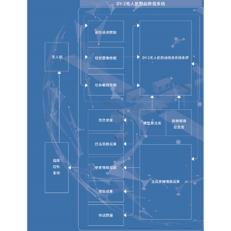
The DY-2 UAV Field Data System from Beijing Kantian Technology Co., Ltd. is a general-purpose GIS and target intelligence tool software. According to the product description, it was developed to address shortcomings of current GIS software in military applications, combining a lightweight GIS framework with specialized functions for target data management and intelligence product production.
- Remote sensing image intelligence production
- Image and intelligence material management
- Intelligence information query and retrieval
- Customized distribution and usage of results
- Embedding in a laptop or image workstation
- Operation in either standalone or networked mode
Beyond these documented functions, the listing does not publish performance figures, supported file formats, licensing terms, or system requirements. Contact us for the datasheet if you need those details for evaluation.
How These Specifications Affect Mission Fit in Logistics and Delivery
Logistics and delivery operations depend on geospatial awareness: corridor mapping, site assessment, and the ability to turn aerial imagery into usable intelligence products that can be queried, retrieved, and distributed to the teams that need them. Each documented DY-2 capability maps to a practical question a logistics operator should ask.
Image intelligence production
For delivery-route planning and infrastructure monitoring, the relevant question is whether the system can turn remote sensing imagery into decision-ready products. DY-2 lists remote sensing image intelligence production as a core function, which is the capability category that route and corridor assessments fall under. Buyers should confirm with the supplier what imagery sources and output formats are supported; contact us for the datasheet for specifics.
Material management and retrieval
Drone logistics programs generate large volumes of imagery and mission records over time. A system's ability to manage image and intelligence material, and to support query and retrieval, determines whether historical missions can be reviewed quickly. When evaluating any solution in this category, ask how data is organized, who can retrieve it, and at what scale the repository has been tested.
Distribution of results
DY-2 documents customized distribution and usage of results. In an enterprise context, this specification area governs how intelligence outputs reach operations teams, planners, and stakeholders. Ask suppliers how distribution is controlled, what customization is available, and whether usage rights can be differentiated by user or role.
Deployment Specifications: Standalone vs. Networked
Deployment mode is one of the most consequential specifications for field programs, and it is explicitly documented for DY-2: the system can be embedded in a laptop or image workstation and can operate either standalone or networked. This matters for two common logistics scenarios.
- Forward and remote operations: A standalone deployment on a laptop suits teams working at temporary sites or in areas where network connectivity cannot be assumed. Latin American logistics operations covering dispersed rural and regional routes often face exactly this constraint, which makes the standalone option worth confirming in writing during procurement.
- Connected operations centers: Networked mode supports teams that need shared access to data and intelligence products across sites. Buyers should ask the supplier about network architecture, connectivity prerequisites, and multi-user behavior; the product listing does not detail these, so contact us for the datasheet.
Comparing Solutions Within the Category
The Solutions category spans different problem domains, so a side-by-side comparison should focus on what each system is built to do, as documented in its listing, rather than on invented performance rankings.
| Solution | Documented core focus | Documented deployment characteristics |
|---|---|---|
| DY-2 UAV Field Data System (Beijing Kantian Technology) | GIS and target intelligence tool software: remote sensing image intelligence production, material management, query and retrieval, customized distribution of results | Embedded in a laptop or image workstation; operates standalone or networked |
| MXNAVI Low-Altitude Intelligent Networked System (Shenyang Mxnavi) | Low-altitude digital aeronautical chart as data foundation, intelligent computing engine as core, software platform as service interface | Integrated with five hardware categories: communication, navigation, surveillance, meteorology, and counter-UAS, for government and enterprise clients |
| Multi-targets Tracking Module (Shenzhen Lingying Intelligence Technology) | AI target detection and tracking, with multi-scenario adaptive optimization and real-time edge AI deployment | Supports embedded AI chips processing over 60 frames of 1080p video per second, per the supplier listing |
| Train obstacle detection system (Jiangsu Huimin Traffic Facility) | Lidar and video multi-sensor fusion with AI algorithms for railway obstacle detection and alarm strategy | Front-mounted or rear-mounted; adapted to different railway environments and train models |
The takeaway for buyers: DY-2 addresses the geospatial data and intelligence-production layer, while the other solutions address low-altitude airspace management, real-time tracking, or rail-specific sensing. Choosing among them starts with defining which layer of your operation the solution must serve.
What to Ask Suppliers Before Procuring a UAV Solution
Because solution listings are necessarily summary-level, procurement teams should convert every vague area into a written question. A practical checklist:
- Functional scope: Which of the documented functions are included in the base package, and which require additional modules or licensing?
- System requirements: What are the minimum specifications for the laptop or image workstation the software is embedded in? Contact us for the datasheet where a listing is silent.
- Network architecture: In networked mode, what connectivity, bandwidth, and security assumptions does the system make?
- Data handling: What image formats, data volumes, and retrieval workloads does the material-management function support?
- Integration: How does the solution exchange data with existing GIS, fleet-management, or enterprise systems?
- Training and support: What onboarding, documentation, and post-deployment support is available, particularly for teams operating across multiple countries or languages?
Evaluation Notes for Buyers in Latin America
For logistics teams operating in Latin America, long distances between hubs and variable connectivity make the standalone-versus-networked specification especially important. When shortlisting solutions, ask each supplier to demonstrate the system running in standalone mode on the hardware class you intend to deploy, and to document what functionality changes when the system is networked. Also confirm language support, localization of interfaces and outputs, and any regional support arrangements. None of these points are covered in the DY-2 listing, so request them directly: contact us for the datasheet and supplier clarification.
Finally, match the purchase to the workflow, not the brochure. A geospatial intelligence system such as the DY-2 is a data-layer investment: it is worth specifying precisely how imagery intelligence will be produced, stored, retrieved, and distributed in your operation before committing budget, and it is worth pairing that decision with a clear statement of which other solution layers, if any, your program needs.
Featured product
DY-2 UAV Field Data System
This system is primarily developed as a general-purpose GIS and target intelligence tool software, addressing the shortcomings of current GIS software in military applications. Built on a lightweight GIS framework, it integrates specialized needs for target data management and intelligence product production,...
Products mentioned in this guide

MXNAVI Low-Altitude Intelligent Networked System
The MXNavi Low-Altitude Intelligent Networked System establishes a low-altitude digital aeronautical chart as its data foundation and an intelligent computing engine as its...
View product details →
Multi-targets Tracking Module
1) Ultra-high Precision Target Detection: It delivers exceptionalperformance across both urban and wild environments, achieving over99.8% accuracy. The system identifies targets...
View product details →
Train obstacle detection system
This product adopts high-precision lidar and video multi-sensor fusion, leveraging the characteristics of different sensors in various environments. Through artificial...
View product details →Frequently asked questions
What is the DY-2 UAV Field Data System designed for?
It is a general-purpose GIS and target intelligence tool software built on a lightweight GIS framework. It integrates target data management and intelligence product production into a customized intelligence application system, supporting remote sensing image intelligence production, image and intelligence material management, intelligence information query and retrieval, and customized distribution and usage of results.
Can the DY-2 operate in the field without network connectivity?
Yes. The product documentation states the system can be embedded in a laptop or image workstation and can operate either standalone or networked. For details on network requirements and standalone functionality limits, contact us for the datasheet.
Are performance figures or system requirements published for DY-2?
No. The published listing describes the system's functions and deployment modes but does not include performance figures, supported formats, or hardware requirements. Contact us for the datasheet to obtain those details.
Is the DY-2 relevant to logistics and delivery operations?
The documented capabilities, such as remote sensing image intelligence production, material management, query and retrieval, and distribution of results, correspond to geospatial data functions that logistics programs commonly need. Whether the system fits a specific delivery or corridor-monitoring workflow should be confirmed with the supplier, as the listing does not describe logistics-specific use cases.
How does DY-2 compare with other Solutions listed on SkyDrone Max?
They address different layers. DY-2 focuses on GIS and intelligence data production and management; the MXNAVI Low-Altitude Intelligent Networked System addresses low-altitude airspace safety control with communication, navigation, surveillance, meteorology, and counter-UAS hardware; the Multi-targets Tracking Module addresses AI-based detection and tracking; and the train obstacle detection system addresses rail-specific sensing. The comparisons above reflect only what each supplier's listing documents.
Need help selecting the right system?
Tell us your mission, payload, and operating environment. Our team will help you compare options and request the right datasheets from verified suppliers.