A low-altitude defense solution for key areas and units is an integrated system that detects, tracks, and manages unauthorized drone activity around protected facilities. For public safety agencies and emergency response organizations, the core question is not whether drones pose a risk—it is how to position, track, assess, and respond to illegal flights in a controlled, repeatable way. The Key area (unit) Low altitude defense solutions from Genenkosy Intelligence Technology (Hangzhou) Co., Ltd. (JNKS) addresses this by combining front-end sensing equipment, end disposal means, and an integrated command and control platform around a single defense objective: keeping protected airspace under structured management.
What the Solution Is and How It Is Built
The JNKS solution is built around the SHIELD central brain, the company's self-developed core system. According to the vendor's description, it combines this central platform with industry understanding and top-level planning capabilities to customize an integrated air-ground UAV defense system for each key area or unit it protects.
Structurally, the system is organized around three components:
- Front-end sensing equipment that monitors the airspace around the protected area
- End disposal means that provide the response measures once a threat is confirmed
- An integrated command and control platform that ties sensing and disposal together under a single operating picture
A defining feature of the design is the use of three levels of defense circles, set according to the airspace invasion threat level. Instead of a single detection perimeter, the system layers its coverage so that the response to a detected drone can be proportionate to where it is and what it appears to be doing.
Who This Solution Is For
The solution is designed for operators responsible for protecting fixed key areas and units—sites where an unauthorized drone incursion carries operational, safety, or security consequences. For public safety and emergency response organizations, this typically includes scenario planning around mass gatherings, critical infrastructure, government compounds, and temporary command locations where airspace integrity matters.
The buyer profile is generally a procurement or operations team rather than an individual pilot. The system is a platform-level purchase: it involves sensing infrastructure, disposal capability, and a command platform, so decisions typically involve site security leadership, technical evaluators, and budget owners together. Organizations in the Middle East evaluating low-altitude security for high-value or high-visibility sites will find the tiered-circle architecture aligns with the perimeter-plus-interior approach common in critical site protection planning.
The Operational Problems It Addresses
Unauthorized drone flights around protected sites create a specific set of problems that ordinary surveillance does not solve. The JNKS solution is described as targeting four of them:
- Accurate positioning — knowing precisely where an intruding drone is, not simply that something has been detected
- Trajectory tracking — following the drone's flight path so its intent and origin can be assessed
- Situation determination — building a situational picture that allows operators to judge whether a flight is a genuine threat or a benign presence
- Reasonable and scientific disposal — responding to illegal flying drones and drone flyers in a manner that is proportionate and defensible, rather than improvised
The last point matters most for public safety buyers. A response that is too weak fails the mission; one that is too aggressive creates legal and safety exposure of its own. The three-tier defense circle structure exists precisely to support graduated response: the level of airspace invasion threat determines the level of intervention.
How the Three Defense Circles Work in Practice
While the vendor's published description does not enumerate the exact parameters of each circle—contact us for the datasheet—the architecture principle is clear from the product description. Outer circles handle detection and early warning, giving operators time to track trajectory and build the situational picture. Inner circles, closer to the defended asset, are where confirmed threats meet disposal means under the direction of the integrated command and control platform.
This layered approach has practical consequences for buyers:
- It reduces pressure on operators to make disposal decisions at the moment of first detection, when information is poorest
- It creates a documented escalation path, which supports accountability in public safety operations
- It allows the system to distinguish between a drone that has strayed near a perimeter and one that has penetrated toward the protected asset itself
What Buyers Should Verify Before Purchasing
Because this is a customized, site-integrated system, the product listing alone does not answer every procurement question. Teams evaluating the solution should request and verify the following directly from Genenkosy Intelligence Technology (Hangzhou) Co., Ltd. or through the marketplace:
- Detection performance details: ranges, coverage, and sensing modalities used in the front-end equipment—contact us for the datasheet
- Disposal methods: what end disposal means are included, and their legal status in your operating jurisdiction
- Platform integration: how the SHIELD central brain interfaces with existing command systems, sensors, and communication infrastructure at your site
- Customization scope: how the top-level planning process works, what site data the vendor requires, and what the deployment timeline looks like
- Certification and compliance documentation: request current certificates and regulatory approvals relevant to your country—contact us for the datasheet
- Pricing and delivery terms: not published in the listing—contact us for the datasheet
Buyers in the Middle East should additionally confirm regional regulatory alignment for counter-UAS operations, since disposal authorities are governed differently across jurisdictions. The vendor's emphasis on customized top-level planning suggests the system is configured per deployment rather than sold as a fixed off-the-shelf package, which makes early engagement with the vendor on site requirements especially important.
How It Fits Alongside Other System Platforms
The main product sits in a category of low-altitude system platforms that buyers often evaluate together. Two related products on the marketplace provide useful context for how these platforms differ in purpose:
| Product | Primary focus | Relevant to |
|---|---|---|
| Key area (unit) Low altitude defense solutions (JNKS) | Air-ground UAV defense around key areas, with three-tier defense circles and integrated command and control | Public safety and site security teams protecting fixed assets |
| Low-Altitude Master (DASPATIAL TECHNOLOGY CO.,LTD.) | Integrated low-altitude telemetry combining real-world 3D modeling with UAV inspection, control, and AI analysis | Teams needing surveying, remote sensing, and 3D spatial perception for low-altitude management |
| Low-altitude Digital Smart Management Platform – Standard Edition (Bytech Technology Co., Ltd.) | AIoT-based digital management covering intelligent sensing, inspection, decision-making, and command and control | Government agencies, enterprises, schools, hospitals, and cultural and tourism organizations pursuing digital management |
These are not direct substitutes. The JNKS product is purpose-built for defense of a protected area, while the related platforms center on broader low-altitude telemetry and digital management. Buyers should select based on their primary mission: protection of a key area versus general low-altitude operations management.
Procurement Guidance for Public Safety Teams
For procurement teams moving from evaluation to purchase, a practical sequence is as follows. First, define the protected area precisely: its boundaries, the airspace around it, and the threat scenarios your agency must plan for. Second, request the full datasheet and customization proposal from the vendor, since the listed description confirms capability areas but not specific performance figures—contact us for the datasheet. Third, involve your legal and regulatory advisors on disposal authority early, because the response side of any counter-UAS system must fit within your jurisdiction's rules. Fourth, plan for integration testing with existing command infrastructure before full deployment. Finally, budget for the operational side—training, procedures for graduated response across the three defense circles, and ongoing support—not just the initial hardware and platform cost.
The strongest buying decisions in this category come from teams that treat the system as an operating capability rather than an equipment purchase. The JNKS solution's own design language—integration of sensing, disposal, and command around a defined defense objective—reflects that same premise, and vendors that offer top-level planning support can typically translate site-specific requirements into a workable deployment.

Featured product
Key area (unit) Low altitude defense solutions
The key area (unit) low altitude defense solution of JNKS is based on the self-developed SHIELD central brain, combined with profound industry understanding and innovative top-level planning capabilities, customized and built an integrated airground UAV defense system around the defense objectives of key areas (unit),...
Products mentioned in this guide
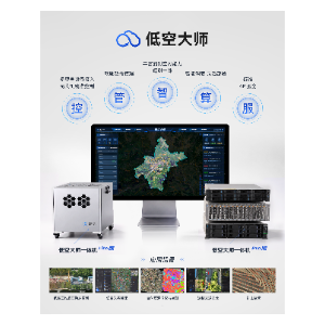
Low-Altitude Master—Integrated Low-Altitude Telemetry Product Solution
Low-Altitude Master—Integrated Low-Altitude Telemetry Product Solution Low-Altitude Master is a comprehensive solution that integrates real-world 3D modeling with low-altitude...
View product details →
Huifeixing Mini Program
Huifeixing is a digital comprehensive service platform for the entire industrial chain of drones. Backed by professional CAAC-accredited training institutions and systematic plant...
View product details →
Low-altitude Digital Smart Management Platform – Standard Edition
Low-altitude Digital Intelligent Management Platform – Tianjixing is dedicated to leveraging AIoT technologies to empower applications in the low-altitude economy. By utilizing...
View product details →Frequently asked questions
What does the Key area (unit) Low altitude defense solution actually do?
It is an integrated air-ground UAV defense system for protecting key areas and units. Built on the self-developed SHIELD central brain, it combines front-end sensing equipment, end disposal means, and an integrated command and control platform to achieve accurate positioning, trajectory tracking, situation determination, and reasonable disposal of illegal flying drones and drone flyers.
What are the three levels of defense circles?
The system sets three levels of defense circles according to the airspace invasion threat level. The published description confirms the tiered structure and its purpose—scaling response to threat level—but does not publish the specific parameters of each circle. Contact us for the datasheet.
Who is this solution intended for?
Organizations responsible for the security of key areas and units, particularly public safety and emergency response teams that need structured detection, tracking, and disposal of unauthorized drones around protected facilities.
Can the system be customized for a specific site?
Yes. The vendor states the solution is customized and built around the defense objectives of each key area or unit, relying on its industry understanding and top-level planning capabilities. Specific customization requirements and scope should be confirmed with the vendor—contact us for the datasheet.
How much does it cost and what certifications does it carry?
Pricing and certification details are not published in the product listing. Contact us for the datasheet to obtain current pricing, certification, and compliance documentation for your region.
Need help selecting the right system?
Tell us your mission, payload, and operating environment. Our team will help you compare options and request the right datasheets from verified suppliers.