Low-Altitude Master is an integrated low-altitude telemetry product solution that combines real-world 3D modeling with low-altitude UAV inspection capabilities in a single System Platform. For public safety and emergency response teams, the core value is spatial certainty: the platform assigns precise 3D spatial coordinates to perception data, so what operators see on screen corresponds to an actual, locatable position on the ground—what the vendor describes as "what you see is what you get, and what you see is where it is." This article explains what the platform does, who it serves, which operational problems it addresses, and what procurement teams should verify before purchase.
What Low-Altitude Master Is
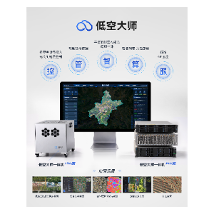
Low-Altitude Master—Integrated Low-Altitude Telemetry Product Solution, developed by DASPATIAL TECHNOLOGY CO.,LTD., is listed on SkyDrone Max under the System Platforms category. It is designed to achieve the integration of surveying and remote sensing, bridging the gap between perception and application services. Rather than treating 3D modeling, UAV inspection, and data analysis as separate workflows, the solution brings them into one integrated telemetry environment.
The platform is built around five core capabilities:
- Control — UAV control for low-altitude operations.
- Management — equipment and data management across connected assets.
- Intelligence — AI analysis applied to collected perception data.
- Computing — computing power scheduling and management.
- Services — storage scheduling and service delivery that connect perception data to end applications.
In practical terms, this means the platform is positioned not as a single drone or a single sensor, but as the software and systems layer that organizes UAVs, equipment, data, AI analysis, and computing resources into a coordinated low-altitude operation.
Who It Is For
The solution is relevant to organizations that operate or oversee UAV fleets in low-altitude airspace and need a unified platform layer rather than point tools. Typical audiences include:
- Public safety agencies running UAV inspection and perception missions that require geographically precise data.
- Emergency response teams that need perception data tied to accurate 3D spatial coordinates for situational awareness.
- Government and enterprise operators managing mixed equipment and data sources under one platform.
- Programs in regions such as Southeast Asia where low-altitude UAV operations are expanding and airspace coordination is a growing procurement concern.
Because it is a System Platform rather than an airframe or payload, the product is best evaluated by teams responsible for architecture and integration—procurement leads, GIS and surveying managers, and operations directors—rather than by pilots selecting a specific aircraft.
Operational Problems It Addresses
Public safety and emergency response operations commonly struggle with fragmented workflows: mapping teams produce 3D models, UAV teams fly inspection missions, and analysis teams work with perception data that lacks reliable spatial context. Low-Altitude Master addresses this fragmentation in three specific ways, according to the product description.
First, it integrates real-world 3D modeling with low-altitude UAV inspection, so surveying and remote sensing occur within one system instead of parallel ones. Second, it closes the gap between perception and application services: raw data collected by UAVs is managed, analyzed with AI, and scheduled through computing and storage resources so it can actually drive operational decisions. Third, by assigning precise 3D spatial coordinates to perception data, it enhances what sensors detect with 3D spatial information—reducing the ambiguity between seeing an object and knowing exactly where that object is.
For emergency response, that last point is operationally significant. A thermal anomaly, a structural change, or a hazard detected from the air is only actionable if responders know its precise 3D position. The platform's integrated telemetry approach is designed to provide that linkage as part of the workflow rather than as a post-processing step.
How It Compares Within the System Platforms Category
SkyDrone Max lists several related System Platforms that serve adjacent roles in low-altitude operations. The table below summarizes each product strictly based on its listed description, so buyers can see where Low-Altitude Master fits alongside alternatives.
| Platform | Brand | Primary Focus (per listed description) |
|---|---|---|
| Low-Altitude Master—Integrated Low-Altitude Telemetry Product Solution | DASPATIAL TECHNOLOGY CO.,LTD. | Integrates real-world 3D modeling with low-altitude UAV inspection; five core capabilities (control, management, intelligence, computing, services); assigns precise 3D spatial coordinates to perception data |
| Qi Yun low altitude safety service management system | Genenkosy Intelligence Technology (Hangzhou) Co., Ltd. | Front-end awareness, communication, digital airspace and service networks; flight planning, route approval, meteorological and alarm services, emergency rescue support |
| Comprehensive Low-altitude Security Management System | The 36th Research Institute of CETC | UAV supervision software integrating UAVs, detection, and countermeasure devices; blacklist/whitelist management, multi-layer monitoring display, 2D/2.5D visualization, flight analysis |
| Drone Management and Control Platform (fire drone command and control platform) | Hangzhou Zhonghui Tonghang Aviation Technology Co., Ltd | Intelligent command system for fire emergency rescue; whole-process control and scheduling of fire drones across monitoring, command, and rescue |
The distinction matters for procurement scoping: the Qi Yun system and the CETC platform emphasize airspace service management and security supervision, while the fire command platform is mission-specific. Low-Altitude Master's differentiator, as described, is the fusion of 3D modeling with UAV telemetry so that perception data carries precise spatial coordinates. These platforms address different layers of a low-altitude program, and buyers should confirm which layer their project requires before shortlisting.
What Buyers Should Verify Before Purchasing
Because Low-Altitude Master is a platform solution, its fit depends heavily on your existing equipment, data infrastructure, and mission profile. The product listing does not include detailed technical specifications, pricing, or certification information—contact us for the datasheet to obtain these details. Before committing budget, procurement teams should verify the following with the vendor:
- Deployment scope: whether the solution is delivered as an on-premises platform, a cloud-hosted service, or a hybrid, and what infrastructure it requires.
- Integration requirements: which UAV models, sensor types, and existing data systems it can connect to for unified equipment and data management.
- 3D modeling requirements: what input data, surveying workflows, and update cadence the real-world 3D modeling component needs in your operating area.
- AI analysis scope: which analytical functions are included and whether custom analysis for your mission types is supported or requires additional services.
- Computing and storage sizing: how the computing power and storage scheduling capabilities scale with your fleet size and data volume.
- Compliance and certifications: applicable aviation, data security, and regional regulatory requirements for your jurisdiction, including any Southeast Asian markets where you operate.
- Pricing and licensing model: commercial terms, support arrangements, and total cost of ownership—request these directly, as they are not published in the listing.
Procurement Recommendations for Public Safety Programs
Treat Low-Altitude Master as an architecture decision, not an equipment purchase. Start by mapping your current workflow—from flight planning and data collection through 3D modeling, analysis, and operational response—and identify where spatial ambiguity or data silos cause delays. If the gap between perception and application is your bottleneck, an integrated telemetry platform is the relevant category to evaluate.
Run a structured evaluation: request the datasheet for specifications not listed on the product page, ask the vendor to demonstrate the 3D coordinate assignment workflow on data similar to your own missions, and confirm how the platform's five capability areas map to your team's roles. Where your program also needs airspace supervision, flight approval services, or fire-specific command functions, review the related platforms listed above in parallel and clarify which capabilities belong in your core platform versus complementary systems. The product listing on SkyDrone Max is the starting point for those vendor conversations.
Featured product
Low-Altitude Master—Integrated Low-Altitude Telemetry Product Solution
Low-Altitude Master—Integrated Low-Altitude Telemetry Product Solution Low-Altitude Master is a comprehensive solution that integrates real-world 3D modeling with low-altitude UAV inspection capabilities to achieve the integration of surveying and remote sensing. It features five core capabilities—control,...
Products mentioned in this guide

Qi Yun low altitude safety service management system
Through the construction of front-end awareness network, communication network, digital airspace network, digital service network, and comprehensive situation map, intelligently...
View product details →
Comprehensive Low-altitude Security Management System
Comprehensive Low-Altitude Security Management System is a comprehensive and versatile unmanned aerial vehicle (UAV) supervision software platform designed for low-altitude...
View product details →
Drone Management and Control Platform
The fire drone command and control platform is a professional intelligent command system tailored for fire emergency rescue, which realizes the whole process control and...
View product details →Frequently asked questions
What is Low-Altitude Master?
Low-Altitude Master—Integrated Low-Altitude Telemetry Product Solution, by DASPATIAL TECHNOLOGY CO.,LTD., is a System Platform that integrates real-world 3D modeling with low-altitude UAV inspection to combine surveying and remote sensing. It provides UAV control, equipment and data management, AI analysis, and computing power and storage scheduling and management.
How does it benefit public safety and emergency response teams?
The platform assigns precise 3D spatial coordinates to perception data, enhancing what UAVs detect with 3D spatial information. This helps emergency teams know not just what a sensor sees but exactly where it is, supporting faster, more accurate operational decisions.
What are the five core capabilities?
Control, management, intelligence, computing, and services. These cover UAV control, equipment and data management, AI analysis, and computing power and storage scheduling and management, bridging the gap between perception and application services.
Does the product listing include technical specifications and pricing?
No. The listing does not publish detailed specifications, pricing, or certification information. Contact us for the datasheet to obtain technical details and commercial terms before procurement.
Are there related platforms I should compare it with?
SkyDrone Max lists related System Platforms, including the Qi Yun low altitude safety service management system (Genenkosy Intelligence Technology), the Comprehensive Low-altitude Security Management System (The 36th Research Institute of CETC), and a fire-focused Drone Management and Control Platform (Hangzhou Zhonghui Tonghang Aviation Technology). Each serves a different layer of low-altitude operations, so review their descriptions to determine which fits your program scope.
Need help selecting the right system?
Tell us your mission, payload, and operating environment. Our team will help you compare options and request the right datasheets from verified suppliers.