Ezsky Low-Altitude Smart Operations Platform
Category: System Platforms
Model: Ezsky
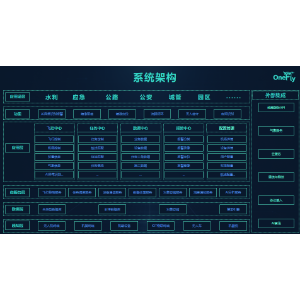
# OneFly Intelligent Operation Platform Flight Control Center: Intelligent cloud control with real-time global monitoring via computer and mobile devices; supports automatic takeoff, flight and landing for unattended operation. Mission Center: One-click mission generation, automatic dispatch and takeoff, real-time monitoring and data collection, forming a fully automatic operation closed loop. Nest Management: Remote monitoring of nest status; supports automatic homing, intelligent charging/battery swapping, and automatic data transmission. Aircraft Management: Real-time viewing of position, flight status and health data, with unified equipment archive management. Data Center: Aggregates flight tracks, imagery, project and other data for unified storage, intelligent analysis and visual display; full-process traceability of flight data, supporting one-click traceability and audit. Alarm Center: 7×24-hour intelligent anomaly detection with customizable threshold rules and instant push notifications, reducing response time from hours to minutes. AI Intelligent Recognition: Vehicle and pedestrian detection, smoke and fire detection (visible light / thermal infrared), no-hard-hat detection, pedestrian flow statistics, automatic model synthesis, etc. --- ## Application Scenarios ### Transportation & Highways Real-time vehicle tracking, directional traffic flow analysis, vehicle type recognition, road debris detection. ### Construction Sites Safety monitoring (no hard hat, hot work safety), quality monitoring (foundation pits, wet joints), progress monitoring (3D modeling). ### Urban Governance Waste accumulation, illegal road occupation, color steel illegal construction, illegal fishing, road encroachment, missing manhole covers. ### Water Conservancy & Water Sources Four types of violations in rivers and lakes, water quality supervision, reservoir inspection, flood control, hidden pipe illegal discharge. ### Forestry Patrol Illegal land occupation, deforestation, pest and disease monitoring, disaster loss statistics, real-scene mapping. ### Public Security & Emergency Response Security for large-scale events, target reconnaissance, accident investigation, emergency rescue (material delivery). ### Power Inspection Transmission line inspection, power grid construction, construction rescue.